Vratsa and Its Surroundings: Mountains, Caves and Bulgarian History
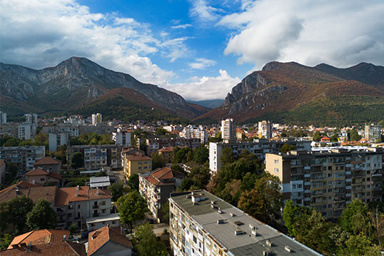
Vratsa lies at the foot of the western Balkan Mountains in northwestern Bulgaria. The city and its surroundings combine archaeological collections, historical monuments and a landscape shaped by limestone cliffs, caves and river valleys. For visitors, the area offers opportunities to explore Bulgarian cultural history alongside the walking routes and natural landmarks of Vrachanski Balkan Nature Park.
Exploring the City
The Regional History Museum provides an introduction to the area’s past. Its collections include archaeological discoveries from Vratsa and the surrounding region, with particular emphasis on Thracian culture.
Among its principal exhibits is the Rogozen Treasure, a collection of 165 silver vessels, 31 of them gilded. Dating mainly from the fifth and fourth centuries BC, the vessels include bowls, jugs and cups decorated with mythological scenes, animals and ornamental motifs. They offer evidence of the craftsmanship, wealth and cultural connections of the Thracian aristocracy.
The museum also manages historical and ethnographic sites elsewhere in Vratsa. These include exhibitions devoted to traditional crafts, domestic life and the Bulgarian National Revival period. Together, they place the region’s ancient discoveries within a broader account of its social and cultural development.
Vrachanski Balkan Nature Park
The mountains surrounding Vratsa form part of Vrachanski Balkan Nature Park. Its protected territory extends across parts of the Vratsa, Montana and Sofia administrative regions.
Much of the landscape consists of limestone and dolomite. Water has gradually dissolved these rocks, creating a karst landscape with caves, underground drainage systems and exposed rock formations. The park contains more than 500 caves, alongside forests, mountain grasslands and deep valleys. It also incorporates the Vratsa Karst Reserve and forms part of the European Natura 2000 network.
One of the most accessible landmarks is Vratsata Gorge, near the city on the road towards Zgorigrad. The Leva River passes between rock walls rising more than 400 metres. The gorge is an established climbing area, with routes of varying difficulty, while remains of the medieval Vratitsa fortress add a historical element to the site.
Ledenika Cave and Mountain Walking
Ledenika is one of the park’s caves developed for tourist visits. Approximately 320 metres long, it contains ten halls with stalactites, stalagmites and other formations. Its name refers to the ice formations that develop near the entrance during winter.
The cave is reached by a mountain road from Vratsa. The surrounding visitor area provides additional activities, and several walking routes pass through the nearby landscape. Current admission arrangements and opening times should be checked with the operator before travelling.
For an outdoor excursion, the Borov Kamak trail starts beyond the village of Zgorigrad and follows the Leva River canyon towards a 63-metre waterfall. The route includes wooden bridges, stairs and sections through beech forest. The park administration notes that the waterfall is particularly active in spring and after rainfall, when the surrounding terrain can also become muddy.
Hristo Botev and the Okolchitsa Area
The Vratsa mountains are closely associated with Hristo Botev, the Bulgarian poet and revolutionary whose detachment fought here in 1876.
The monument on Okolchitsa commemorates Botev and his fighters. It is a focal point for the annual commemorations on 2 June and the endpoint of the Kozloduy–Okolchitsa memorial march. The monument can be reached by road, while walking routes approach the area from nearby villages.
The Okolchitsa monument and the place identified as Botev’s death site are separate locations. The latter lies near Yolkovitsa, approximately two kilometres southwest of Okolchitsa, on the southeastern slope of Kamarata. A marked circular historical route connects visitors with this part of the landscape.
Ritlite and Cherepish Monastery
South of Vratsa, the Iskar Gorge offers further natural and cultural landmarks. Near Lyutibrod, the Ritlite formation consists of parallel upright limestone walls beside the Iskar River. The nearby Rashov Dol locality is associated with a battle involving members of Botev’s detachment after his death.
Cherepish Monastery, dedicated to the Assumption of the Virgin, stands nearby. Its history reaches back to the Second Bulgarian Empire, and it developed as a centre for religious education and manuscript production. It remains an active Orthodox monastery, so visitors should respect services, dress appropriately and keep noise to a minimum.
Planning a Visit
A visit can combine time in the city with separate excursions into the mountains and the Iskar Gorge. The museum, Vratsata, Ledenika, Okolchitsa and the Lyutibrod area provide different perspectives on the region, rather than variations on a single attraction.
When planning walks, distinguish between short educational trails and longer mountain routes. The park administration publishes route descriptions, estimated walking times and maps. These are useful starting points for choosing an itinerary suited to the available time and walking experience.

You May Also Like
Veliko Tarnovo: Bulgaria’s Charming Medieval Capital
March 3, 2023
Unveiling the Enchantment of Bulgaria’s Central Balkan Mountains
August 22, 2023